|
|
|||||||||||||||||
| Point ID: 348 | Downloads | Plots | Site Data | Code: 05BN009 |
|
|
|||||||||||||||||
| Download | |
|---|---|
| Site Descriptor Information | Site Time Series Data |
| Link to all available data | |
| View: | Time Series | All |
| Units: | mm |
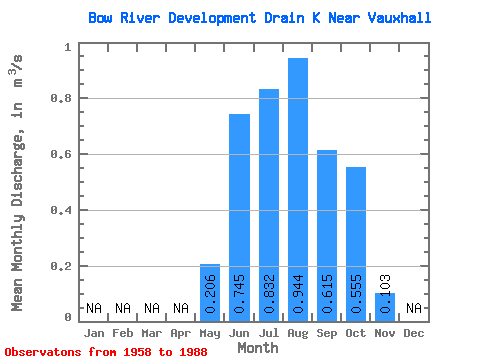
| Statistic | Jan | Feb | Mar | Apr | May | Jun | Jul | Aug | Sep | Oct | Nov | Dec | Annual |
|---|---|---|---|---|---|---|---|---|---|---|---|---|---|
| Mean | 0.21 | 0.74 | 0.83 | 0.94 | 0.61 | 0.56 | 0.10 | ||||||
| Standard Deviation | 0.24 | 0.50 | 0.61 | 0.71 | 0.40 | 0.40 | |||||||
| Min | 0.01 | 0.02 | 0.02 | 0.02 | 0.07 | 0.10 | 0.10 | ||||||
| Max | 0.80 | 1.95 | 2.41 | 2.56 | 1.72 | 1.72 | 0.10 | ||||||
| Coefficient of Variation | 1.16 | 0.68 | 0.74 | 0.75 | 0.65 | 0.73 |
 Return to R-Arctic Net Home Page