|
|
|||||||||||||||||
| Point ID: 346 | Downloads | Plots | Site Data | Code: 05BN007 |
|
|
|||||||||||||||||
| Download | |
|---|---|
| Site Descriptor Information | Site Time Series Data |
| Link to all available data | |
| View: | Time Series | All |
| Units: | mm |
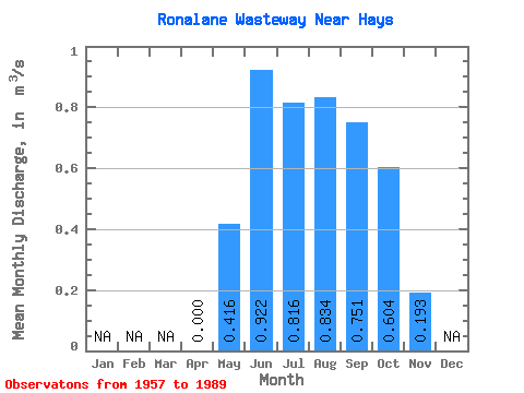
| Statistic | Jan | Feb | Mar | Apr | May | Jun | Jul | Aug | Sep | Oct | Nov | Dec | Annual |
|---|---|---|---|---|---|---|---|---|---|---|---|---|---|
| Mean | 0.00 | 0.42 | 0.92 | 0.82 | 0.83 | 0.75 | 0.60 | 0.19 | |||||
| Standard Deviation | 0.26 | 0.35 | 0.38 | 0.43 | 0.46 | 0.51 | 0.19 | ||||||
| Min | 0.00 | 0.00 | 0.35 | 0.26 | 0.22 | 0.18 | 0.09 | 0.02 | |||||
| Max | 0.00 | 0.94 | 1.57 | 2.09 | 2.14 | 2.30 | 2.51 | 0.50 | |||||
| Coefficient of Variation | 0.63 | 0.38 | 0.47 | 0.52 | 0.61 | 0.85 | 0.98 |
 Return to R-Arctic Net Home Page