|
|
|||||||||||||||||
| Point ID: 342 | Downloads | Plots | Site Data | Code: 05BN003 |
|
|
|||||||||||||||||
| Download | |
|---|---|
| Site Descriptor Information | Site Time Series Data |
| Link to all available data | |
| View: | Time Series | All |
| Units: | mm |
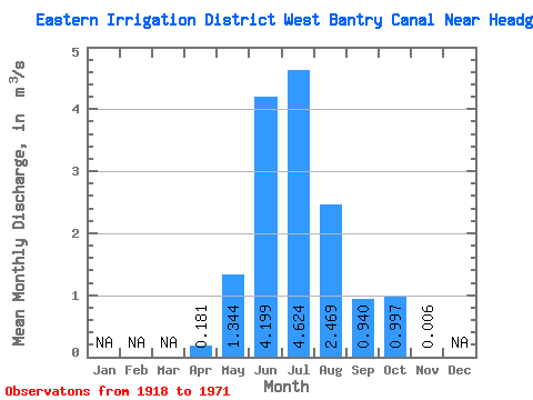
| Statistic | Jan | Feb | Mar | Apr | May | Jun | Jul | Aug | Sep | Oct | Nov | Dec | Annual |
|---|---|---|---|---|---|---|---|---|---|---|---|---|---|
| Mean | 0.18 | 1.34 | 4.20 | 4.62 | 2.47 | 0.94 | 1.00 | 0.01 | |||||
| Standard Deviation | 0.26 | 1.25 | 1.47 | 1.71 | 1.10 | 0.51 | 0.60 | 0.03 | |||||
| Min | 0.00 | 0.01 | 0.92 | 1.03 | 0.24 | 0.28 | 0.07 | 0.00 | |||||
| Max | 0.36 | 4.19 | 6.60 | 6.58 | 4.26 | 2.54 | 2.56 | 0.11 | |||||
| Coefficient of Variation | 1.41 | 0.93 | 0.35 | 0.37 | 0.44 | 0.54 | 0.60 | 4.20 |
 Return to R-Arctic Net Home Page