|
|
|||||||||||||||||
| Point ID: 34 | Downloads | Plots | Site Data | Code: 05AB016 |
|
|
|||||||||||||||||
| Download | |
|---|---|
| Site Descriptor Information | Site Time Series Data |
| Link to all available data | |
| View: | Time Series | All |
| Units: | mm |
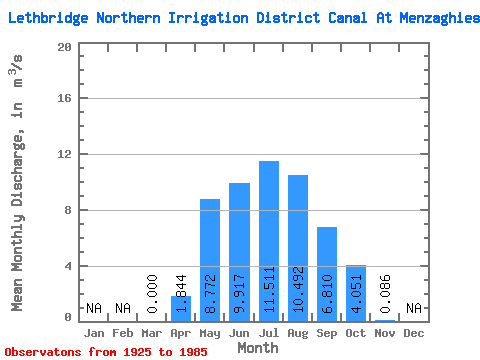
| Statistic | Jan | Feb | Mar | Apr | May | Jun | Jul | Aug | Sep | Oct | Nov | Dec | Annual |
|---|---|---|---|---|---|---|---|---|---|---|---|---|---|
| Mean | 0.00 | 1.84 | 8.77 | 9.92 | 11.51 | 10.49 | 6.81 | 4.05 | 0.09 | ||||
| Standard Deviation | 0.00 | 2.89 | 4.80 | 4.64 | 4.96 | 2.89 | 2.70 | 1.98 | 0.40 | ||||
| Min | 0.00 | 0.00 | 0.00 | 0.32 | 1.24 | 3.63 | 2.08 | 0.00 | 0.00 | ||||
| Max | 0.00 | 9.29 | 22.60 | 18.90 | 18.40 | 16.30 | 14.40 | 8.47 | 2.25 | ||||
| Coefficient of Variation | 1.57 | 0.55 | 0.47 | 0.43 | 0.28 | 0.40 | 0.49 | 4.60 |
 Return to R-Arctic Net Home Page