|
|
|||||||||||||||||
| Point ID: 329 | Downloads | Plots | Site Data | Code: 05BM007 |
|
|
|||||||||||||||||
| Download | |
|---|---|
| Site Descriptor Information | Site Time Series Data |
| Link to all available data | |
| View: | Time Series | All |
| Units: | mm |
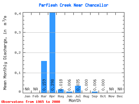
| Statistic | Jan | Feb | Mar | Apr | May | Jun | Jul | Aug | Sep | Oct | Nov | Dec | Annual |
|---|---|---|---|---|---|---|---|---|---|---|---|---|---|
| Mean | 0.16 | 0.40 | 0.02 | 0.01 | 0.04 | 0.00 | 0.01 | 0.00 | |||||
| Standard Deviation | 0.47 | 0.86 | 0.06 | 0.02 | 0.17 | 0.00 | 0.02 | 0.00 | |||||
| Min | 0.00 | 0.00 | 0.00 | 0.00 | 0.00 | 0.00 | 0.00 | 0.00 | |||||
| Max | 2.56 | 3.69 | 0.34 | 0.08 | 0.97 | 0.01 | 0.11 | 0.00 | |||||
| Coefficient of Variation | 2.92 | 2.15 | 3.41 | 2.83 | 4.84 | 5.75 | 4.09 |
 Return to R-Arctic Net Home Page