|
|
|||||||||||||||||
| Point ID: 319 | Downloads | Plots | Site Data | Code: 05BL022 |
|
|
|||||||||||||||||
| Download | |
|---|---|
| Site Descriptor Information | Site Time Series Data |
| Link to all available data | |
| View: | Time Series | All |
| Units: | mm |
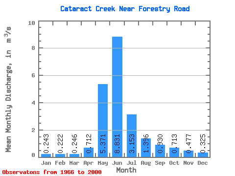
| Statistic | Jan | Feb | Mar | Apr | May | Jun | Jul | Aug | Sep | Oct | Nov | Dec | Annual |
|---|---|---|---|---|---|---|---|---|---|---|---|---|---|
| Mean | 0.24 | 0.22 | 0.25 | 0.71 | 5.37 | 8.83 | 3.15 | 1.40 | 0.93 | 0.71 | 0.48 | 0.33 | 1.87 |
| Standard Deviation | 0.09 | 0.06 | 0.07 | 0.34 | 2.35 | 4.38 | 1.77 | 0.96 | 0.61 | 0.35 | 0.20 | 0.13 | 0.66 |
| Min | 0.11 | 0.11 | 0.14 | 0.22 | 2.24 | 1.90 | 0.97 | 0.58 | 0.40 | 0.40 | 0.23 | 0.15 | 0.99 |
| Max | 0.46 | 0.33 | 0.44 | 1.36 | 11.40 | 19.20 | 8.49 | 5.48 | 3.27 | 1.79 | 0.99 | 0.71 | 3.01 |
| Coefficient of Variation | 0.36 | 0.28 | 0.28 | 0.48 | 0.44 | 0.50 | 0.56 | 0.69 | 0.66 | 0.49 | 0.42 | 0.41 | 0.35 |
 Return to R-Arctic Net Home Page