|
|
|||||||||||||||||
| Point ID: 3133 | Downloads | Plots | Site Data | Code: 06GA001 |
|
|
|||||||||||||||||
| Download | |
|---|---|
| Site Descriptor Information | Site Time Series Data |
| Link to all available data | |
| View: | Time Series | All |
| Units: | mm |
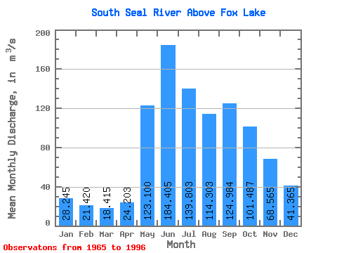
| Statistic | Jan | Feb | Mar | Apr | May | Jun | Jul | Aug | Sep | Oct | Nov | Dec | Annual |
|---|---|---|---|---|---|---|---|---|---|---|---|---|---|
| Mean | 28.25 | 21.42 | 18.41 | 24.20 | 123.10 | 184.41 | 139.80 | 114.30 | 124.98 | 101.49 | 68.56 | 41.37 | 76.99 |
| Standard Deviation | 9.95 | 6.32 | 5.32 | 17.50 | 59.88 | 74.73 | 64.88 | 67.95 | 91.08 | 63.51 | 38.29 | 19.91 | 20.52 |
| Min | 12.70 | 10.00 | 8.74 | 8.77 | 19.50 | 63.00 | 35.30 | 36.00 | 28.30 | 21.50 | 19.20 | 17.50 | 49.92 |
| Max | 53.80 | 33.80 | 29.50 | 81.60 | 216.00 | 360.00 | 294.00 | 279.00 | 357.00 | 258.00 | 180.00 | 104.00 | 122.88 |
| Coefficient of Variation | 0.35 | 0.29 | 0.29 | 0.72 | 0.49 | 0.41 | 0.46 | 0.59 | 0.73 | 0.63 | 0.56 | 0.48 | 0.27 |
 Return to R-Arctic Net Home Page