|
|
|||||||||||||||||
| Point ID: 3128 | Downloads | Plots | Site Data | Code: 06FB001 |
|
|
|||||||||||||||||
| Download | |
|---|---|
| Site Descriptor Information | Site Time Series Data |
| Link to all available data | |
| View: | Time Series | All |
| Units: | mm |
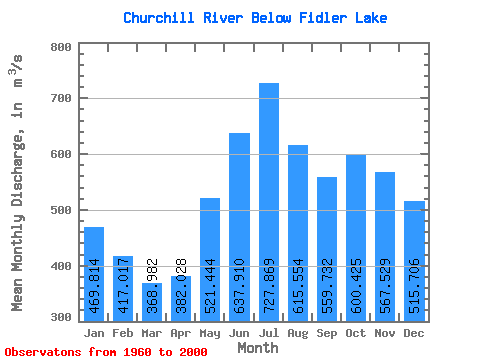
| Statistic | Jan | Feb | Mar | Apr | May | Jun | Jul | Aug | Sep | Oct | Nov | Dec | Annual |
|---|---|---|---|---|---|---|---|---|---|---|---|---|---|
| Mean | 469.81 | 417.02 | 368.98 | 382.03 | 521.44 | 637.91 | 727.87 | 615.55 | 559.73 | 600.42 | 567.53 | 515.71 | 508.91 |
| Standard Deviation | 442.41 | 406.67 | 390.75 | 408.03 | 458.34 | 543.82 | 643.94 | 561.16 | 534.89 | 546.89 | 503.60 | 479.20 | 450.39 |
| Min | 87.80 | 68.40 | 55.80 | 47.90 | 72.70 | 92.20 | 69.20 | 45.10 | 37.60 | 55.50 | 138.00 | 114.00 | 108.60 |
| Max | 1290.00 | 1190.00 | 1130.00 | 1100.00 | 1370.00 | 1750.00 | 2140.00 | 1660.00 | 1550.00 | 1530.00 | 1540.00 | 1380.00 | 1333.33 |
| Coefficient of Variation | 0.94 | 0.97 | 1.06 | 1.07 | 0.88 | 0.85 | 0.89 | 0.91 | 0.96 | 0.91 | 0.89 | 0.93 | 0.89 |
 Return to R-Arctic Net Home Page