|
|
|||||||||||||||||
| Point ID: 3115 | Downloads | Plots | Site Data | Code: 05UF007 |
|
|
|||||||||||||||||
| Download | |
|---|---|
| Site Descriptor Information | Site Time Series Data |
| Link to all available data | |
| View: | Time Series | All |
| Units: | mm |
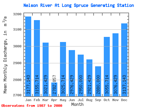
| Statistic | Jan | Feb | Mar | Apr | May | Jun | Jul | Aug | Sep | Oct | Nov | Dec | Annual |
|---|---|---|---|---|---|---|---|---|---|---|---|---|---|
| Mean | 3177.14 | 3155.71 | 3021.43 | 2782.86 | 3025.71 | 2976.43 | 2950.00 | 2921.43 | 2880.00 | 3055.71 | 3076.43 | 3137.14 | 3013.33 |
| Standard Deviation | 496.46 | 480.57 | 506.75 | 596.60 | 601.39 | 1028.42 | 1127.47 | 927.62 | 658.30 | 604.85 | 498.48 | 473.54 | 543.01 |
| Min | 2240.00 | 2260.00 | 2210.00 | 1980.00 | 2120.00 | 1730.00 | 1810.00 | 1610.00 | 1870.00 | 1820.00 | 2110.00 | 2290.00 | 2246.67 |
| Max | 4070.00 | 3960.00 | 3810.00 | 3910.00 | 4370.00 | 5310.00 | 5280.00 | 4790.00 | 4150.00 | 3790.00 | 3940.00 | 3990.00 | 4180.00 |
| Coefficient of Variation | 0.16 | 0.15 | 0.17 | 0.21 | 0.20 | 0.35 | 0.38 | 0.32 | 0.23 | 0.20 | 0.16 | 0.15 | 0.18 |
 Return to R-Arctic Net Home Page