|
|
|||||||||||||||||
| Point ID: 3106 | Downloads | Plots | Site Data | Code: 05UB009 |
|
|
|||||||||||||||||
| Download | |
|---|---|
| Site Descriptor Information | Site Time Series Data |
| Link to all available data | |
| View: | Time Series | All |
| Units: | mm |
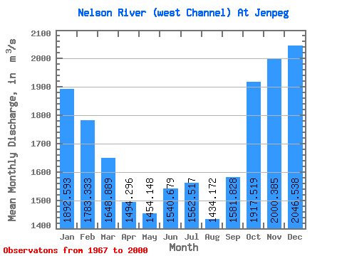
| Statistic | Jan | Feb | Mar | Apr | May | Jun | Jul | Aug | Sep | Oct | Nov | Dec | Annual |
|---|---|---|---|---|---|---|---|---|---|---|---|---|---|
| Mean | 1892.59 | 1783.33 | 1648.89 | 1494.30 | 1454.15 | 1540.68 | 1562.52 | 1434.17 | 1581.83 | 1917.52 | 2000.38 | 2046.54 | 1654.00 |
| Standard Deviation | 328.10 | 324.84 | 336.54 | 441.30 | 923.25 | 1060.53 | 993.61 | 694.44 | 642.74 | 402.62 | 247.17 | 391.38 | 410.67 |
| Min | 1240.00 | 1150.00 | 1090.00 | 569.00 | 469.00 | 466.00 | 460.00 | 480.00 | 513.00 | 923.00 | 1360.00 | 1340.00 | 931.25 |
| Max | 2410.00 | 2330.00 | 2280.00 | 2310.00 | 3360.00 | 3710.00 | 3560.00 | 2770.00 | 3230.00 | 2960.00 | 2430.00 | 2810.00 | 2508.33 |
| Coefficient of Variation | 0.17 | 0.18 | 0.20 | 0.29 | 0.64 | 0.69 | 0.64 | 0.48 | 0.41 | 0.21 | 0.12 | 0.19 | 0.25 |
 Return to R-Arctic Net Home Page