|
|
|||||||||||||||||
| Point ID: 3103 | Downloads | Plots | Site Data | Code: 05TG003 |
|
|
|||||||||||||||||
| Download | |
|---|---|
| Site Descriptor Information | Site Time Series Data |
| Link to all available data | |
| View: | Time Series | All |
| Units: | mm |
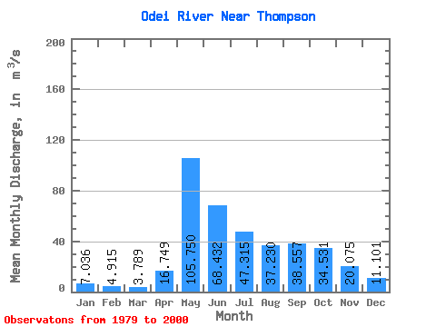
| Statistic | Jan | Feb | Mar | Apr | May | Jun | Jul | Aug | Sep | Oct | Nov | Dec | Annual |
|---|---|---|---|---|---|---|---|---|---|---|---|---|---|
| Mean | 7.04 | 4.92 | 3.79 | 16.75 | 105.75 | 68.43 | 47.31 | 37.23 | 38.56 | 34.53 | 20.07 | 11.10 | 33.07 |
| Standard Deviation | 5.37 | 3.79 | 2.55 | 21.34 | 44.33 | 22.80 | 25.24 | 22.29 | 27.91 | 21.88 | 10.88 | 7.24 | 10.25 |
| Min | 0.90 | 0.55 | 0.46 | 1.15 | 35.90 | 34.70 | 12.70 | 13.10 | 11.00 | 8.96 | 8.08 | 1.84 | 16.94 |
| Max | 19.00 | 13.90 | 8.69 | 84.90 | 202.00 | 108.00 | 116.00 | 83.60 | 106.00 | 88.40 | 47.00 | 26.00 | 51.17 |
| Coefficient of Variation | 0.76 | 0.77 | 0.67 | 1.27 | 0.42 | 0.33 | 0.53 | 0.60 | 0.72 | 0.63 | 0.54 | 0.65 | 0.31 |
 Return to R-Arctic Net Home Page