|
|
|||||||||||||||||
| Point ID: 3101 | Downloads | Plots | Site Data | Code: 05TG001 |
|
|
|||||||||||||||||
| Download | |
|---|---|
| Site Descriptor Information | Site Time Series Data |
| Link to all available data | |
| View: | Time Series | All |
| Units: | mm |
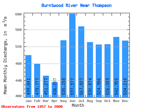
| Statistic | Jan | Feb | Mar | Apr | May | Jun | Jul | Aug | Sep | Oct | Nov | Dec | Annual |
|---|---|---|---|---|---|---|---|---|---|---|---|---|---|
| Mean | 499.84 | 479.78 | 451.28 | 436.21 | 535.16 | 597.98 | 567.84 | 530.87 | 524.99 | 526.06 | 542.96 | 534.22 | 521.74 |
| Standard Deviation | 428.95 | 423.23 | 411.92 | 398.02 | 356.99 | 334.08 | 356.21 | 377.87 | 390.41 | 393.43 | 410.36 | 430.13 | 379.77 |
| Min | 9.45 | 8.39 | 7.83 | 8.52 | 68.90 | 146.00 | 108.00 | 65.40 | 41.90 | 32.60 | 23.60 | 13.70 | 47.72 |
| Max | 1100.00 | 1100.00 | 1170.00 | 1180.00 | 1220.00 | 1360.00 | 1390.00 | 1150.00 | 1080.00 | 1100.00 | 1100.00 | 1100.00 | 1136.58 |
| Coefficient of Variation | 0.86 | 0.88 | 0.91 | 0.91 | 0.67 | 0.56 | 0.63 | 0.71 | 0.74 | 0.75 | 0.76 | 0.81 | 0.73 |
 Return to R-Arctic Net Home Page