|
|
|||||||||||||||||
| Point ID: 3094 | Downloads | Plots | Site Data | Code: 05SD004 |
|
|
|||||||||||||||||
| Download | |
|---|---|
| Site Descriptor Information | Site Time Series Data |
| Link to all available data | |
| View: | Time Series | All |
| Units: | mm |
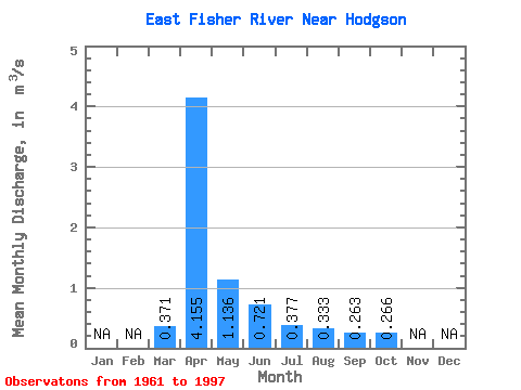
| Statistic | Jan | Feb | Mar | Apr | May | Jun | Jul | Aug | Sep | Oct | Nov | Dec | Annual |
|---|---|---|---|---|---|---|---|---|---|---|---|---|---|
| Mean | 0.37 | 4.16 | 1.14 | 0.72 | 0.38 | 0.33 | 0.26 | 0.27 | |||||
| Standard Deviation | 0.66 | 4.04 | 1.62 | 0.88 | 0.16 | 0.20 | 0.15 | 0.12 | |||||
| Min | 0.03 | 0.36 | 0.17 | 0.15 | 0.19 | 0.12 | 0.11 | 0.14 | |||||
| Max | 3.64 | 17.90 | 9.07 | 4.44 | 0.70 | 0.87 | 0.52 | 0.50 | |||||
| Coefficient of Variation | 1.79 | 0.97 | 1.43 | 1.22 | 0.42 | 0.61 | 0.59 | 0.44 |
 Return to R-Arctic Net Home Page