|
|
|||||||||||||||||
| Point ID: 3093 | Downloads | Plots | Site Data | Code: 05SD003 |
|
|
|||||||||||||||||
| Download | |
|---|---|
| Site Descriptor Information | Site Time Series Data |
| Link to all available data | |
| View: | Time Series | All |
| Units: | mm |
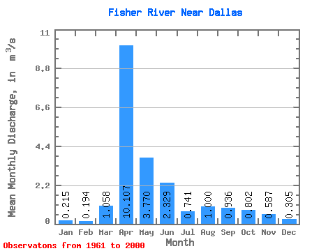
| Statistic | Jan | Feb | Mar | Apr | May | Jun | Jul | Aug | Sep | Oct | Nov | Dec | Annual |
|---|---|---|---|---|---|---|---|---|---|---|---|---|---|
| Mean | 0.21 | 0.19 | 1.06 | 10.11 | 3.77 | 2.33 | 0.74 | 1.00 | 0.94 | 0.80 | 0.59 | 0.30 | 1.83 |
| Standard Deviation | 0.13 | 0.12 | 2.47 | 10.27 | 5.56 | 3.63 | 0.54 | 2.41 | 2.63 | 1.19 | 0.71 | 0.18 | 1.42 |
| Min | 0.06 | 0.02 | 0.06 | 0.52 | 0.24 | 0.25 | 0.22 | 0.10 | 0.14 | 0.15 | 0.18 | 0.09 | 0.28 |
| Max | 0.65 | 0.54 | 14.20 | 46.80 | 28.10 | 18.90 | 3.06 | 14.10 | 16.10 | 6.35 | 3.86 | 0.89 | 5.85 |
| Coefficient of Variation | 0.60 | 0.61 | 2.34 | 1.02 | 1.48 | 1.56 | 0.73 | 2.41 | 2.81 | 1.48 | 1.20 | 0.58 | 0.78 |
 Return to R-Arctic Net Home Page