|
|
|||||||||||||||||
| Point ID: 3085 | Downloads | Plots | Site Data | Code: 05RE001 |
|
|
|||||||||||||||||
| Download | |
|---|---|
| Site Descriptor Information | Site Time Series Data |
| Link to all available data | |
| View: | Time Series | All |
| Units: | mm |
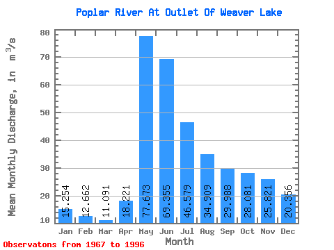
| Statistic | Jan | Feb | Mar | Apr | May | Jun | Jul | Aug | Sep | Oct | Nov | Dec | Annual |
|---|---|---|---|---|---|---|---|---|---|---|---|---|---|
| Mean | 15.25 | 12.66 | 11.09 | 18.22 | 77.67 | 69.36 | 46.58 | 34.91 | 29.99 | 28.08 | 25.82 | 20.36 | 32.56 |
| Standard Deviation | 5.38 | 3.92 | 3.27 | 10.88 | 55.05 | 46.89 | 28.26 | 29.48 | 35.26 | 29.93 | 17.95 | 9.69 | 14.57 |
| Min | 3.15 | 2.99 | 3.13 | 3.35 | 5.51 | 18.80 | 12.90 | 7.39 | 4.49 | 3.80 | 3.63 | 3.32 | 9.21 |
| Max | 25.80 | 18.40 | 15.10 | 51.20 | 203.00 | 246.00 | 111.00 | 141.00 | 177.00 | 153.00 | 88.40 | 45.00 | 78.67 |
| Coefficient of Variation | 0.35 | 0.31 | 0.29 | 0.60 | 0.71 | 0.68 | 0.61 | 0.84 | 1.18 | 1.07 | 0.69 | 0.48 | 0.45 |
 Return to R-Arctic Net Home Page