|
|
|||||||||||||||||
| Point ID: 3065 | Downloads | Plots | Site Data | Code: 05PF049 |
|
|
|||||||||||||||||
| Download | |
|---|---|
| Site Descriptor Information | Site Time Series Data |
| Link to all available data | |
| View: | Time Series | All |
| Units: | mm |
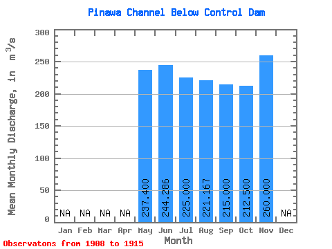
| Statistic | Jan | Feb | Mar | Apr | May | Jun | Jul | Aug | Sep | Oct | Nov | Dec | Annual |
|---|---|---|---|---|---|---|---|---|---|---|---|---|---|
| Mean | 237.40 | 244.29 | 225.00 | 221.17 | 215.00 | 212.50 | 260.00 | ||||||
| Standard Deviation | 57.95 | 63.15 | 71.99 | 72.87 | 61.77 | 47.74 | |||||||
| Min | 176.00 | 150.00 | 156.00 | 148.00 | 157.00 | 162.00 | 260.00 | ||||||
| Max | 312.00 | 294.00 | 299.00 | 296.00 | 275.00 | 272.00 | 260.00 | ||||||
| Coefficient of Variation | 0.24 | 0.26 | 0.32 | 0.33 | 0.29 | 0.23 |
 Return to R-Arctic Net Home Page