|
|
|||||||||||||||||
| Point ID: 3062 | Downloads | Plots | Site Data | Code: 05OJ020 |
|
|
|||||||||||||||||
| Download | |
|---|---|
| Site Descriptor Information | Site Time Series Data |
| Link to all available data | |
| View: | Time Series | All |
| Units: | mm |
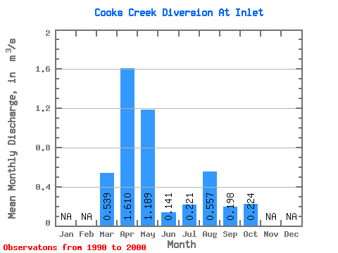
| Statistic | Jan | Feb | Mar | Apr | May | Jun | Jul | Aug | Sep | Oct | Nov | Dec | Annual |
|---|---|---|---|---|---|---|---|---|---|---|---|---|---|
| Mean | 0.54 | 1.61 | 1.19 | 0.14 | 0.22 | 0.56 | 0.20 | 0.22 | |||||
| Standard Deviation | 0.96 | 2.01 | 1.98 | 0.20 | 0.54 | 1.44 | 0.38 | 0.53 | |||||
| Min | 0.00 | 0.00 | 0.00 | 0.00 | 0.00 | 0.00 | 0.00 | 0.00 | |||||
| Max | 3.02 | 5.95 | 6.22 | 0.53 | 1.44 | 3.81 | 1.01 | 1.42 | |||||
| Coefficient of Variation | 1.79 | 1.25 | 1.66 | 1.39 | 2.43 | 2.58 | 1.94 | 2.37 |
 Return to R-Arctic Net Home Page