|
|
|||||||||||||||||
| Point ID: 3061 | Downloads | Plots | Site Data | Code: 05OJ019 |
|
|
|||||||||||||||||
| Download | |
|---|---|
| Site Descriptor Information | Site Time Series Data |
| Link to all available data | |
| View: | Time Series | All |
| Units: | mm |
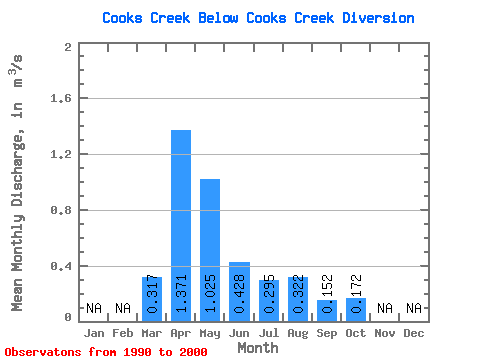
| Statistic | Jan | Feb | Mar | Apr | May | Jun | Jul | Aug | Sep | Oct | Nov | Dec | Annual |
|---|---|---|---|---|---|---|---|---|---|---|---|---|---|
| Mean | 0.32 | 1.37 | 1.02 | 0.43 | 0.29 | 0.32 | 0.15 | 0.17 | |||||
| Standard Deviation | 0.47 | 1.66 | 1.10 | 0.41 | 0.23 | 0.74 | 0.25 | 0.31 | |||||
| Min | 0.00 | 0.12 | 0.02 | 0.05 | 0.04 | 0.00 | 0.00 | 0.00 | |||||
| Max | 1.41 | 5.48 | 3.41 | 1.09 | 0.70 | 2.01 | 0.69 | 0.85 | |||||
| Coefficient of Variation | 1.47 | 1.21 | 1.07 | 0.95 | 0.78 | 2.31 | 1.68 | 1.80 |
 Return to R-Arctic Net Home Page