|
|
|||||||||||||||||
| Point ID: 3060 | Downloads | Plots | Site Data | Code: 05OJ017 |
|
|
|||||||||||||||||
| Download | |
|---|---|
| Site Descriptor Information | Site Time Series Data |
| Link to all available data | |
| View: | Time Series | All |
| Units: | mm |
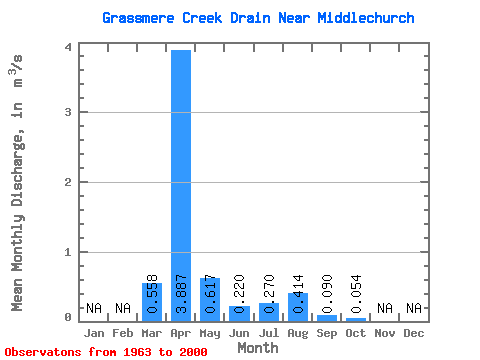
| Statistic | Jan | Feb | Mar | Apr | May | Jun | Jul | Aug | Sep | Oct | Nov | Dec | Annual |
|---|---|---|---|---|---|---|---|---|---|---|---|---|---|
| Mean | 0.56 | 3.89 | 0.62 | 0.22 | 0.27 | 0.41 | 0.09 | 0.05 | |||||
| Standard Deviation | 1.14 | 4.06 | 1.11 | 0.42 | 0.59 | 1.27 | 0.20 | 0.11 | |||||
| Min | 0.00 | 0.02 | 0.00 | 0.01 | 0.00 | 0.00 | 0.00 | 0.00 | |||||
| Max | 4.93 | 14.50 | 4.98 | 2.21 | 2.60 | 6.69 | 0.84 | 0.45 | |||||
| Coefficient of Variation | 2.04 | 1.04 | 1.80 | 1.90 | 2.17 | 3.08 | 2.26 | 1.99 |
 Return to R-Arctic Net Home Page