|
|
|||||||||||||||||
| Point ID: 3056 | Downloads | Plots | Site Data | Code: 05OJ012 |
|
|
|||||||||||||||||
| Download | |
|---|---|
| Site Descriptor Information | Site Time Series Data |
| Link to all available data | |
| View: | Time Series | All |
| Units: | mm |
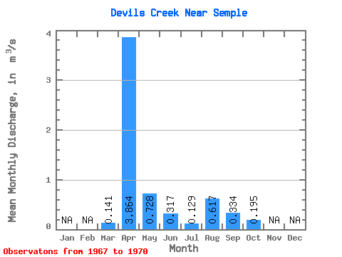
| Statistic | Jan | Feb | Mar | Apr | May | Jun | Jul | Aug | Sep | Oct | Nov | Dec | Annual |
|---|---|---|---|---|---|---|---|---|---|---|---|---|---|
| Mean | 0.14 | 3.86 | 0.73 | 0.32 | 0.13 | 0.62 | 0.33 | 0.20 | |||||
| Standard Deviation | 0.28 | 2.04 | 0.33 | 0.33 | 0.15 | 1.14 | 0.35 | 0.13 | |||||
| Min | 0.00 | 0.95 | 0.44 | 0.01 | 0.00 | 0.01 | 0.01 | 0.02 | |||||
| Max | 0.56 | 5.43 | 1.18 | 0.78 | 0.33 | 2.32 | 0.72 | 0.30 | |||||
| Coefficient of Variation | 2.00 | 0.53 | 0.45 | 1.05 | 1.16 | 1.84 | 1.06 | 0.67 |
 Return to R-Arctic Net Home Page