|
|
|||||||||||||||||
| Point ID: 3055 | Downloads | Plots | Site Data | Code: 05OJ010 |
|
|
|||||||||||||||||
| Download | |
|---|---|
| Site Descriptor Information | Site Time Series Data |
| Link to all available data | |
| View: | Time Series | All |
| Units: | mm |
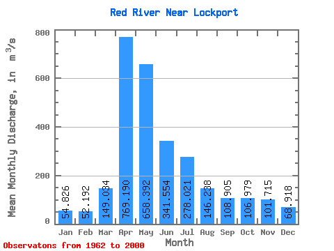
| Statistic | Jan | Feb | Mar | Apr | May | Jun | Jul | Aug | Sep | Oct | Nov | Dec | Annual |
|---|---|---|---|---|---|---|---|---|---|---|---|---|---|
| Mean | 54.83 | 52.19 | 149.03 | 769.19 | 658.39 | 341.55 | 278.02 | 146.24 | 108.91 | 106.98 | 101.72 | 68.92 | 235.10 |
| Standard Deviation | 24.99 | 22.25 | 161.07 | 433.56 | 664.71 | 225.67 | 221.21 | 168.33 | 86.70 | 61.15 | 98.31 | 40.39 | 121.91 |
| Min | 13.90 | 15.70 | 25.80 | 84.00 | 57.90 | 47.30 | 42.90 | 21.80 | 22.50 | 26.20 | 15.60 | 14.60 | 51.03 |
| Max | 96.40 | 95.20 | 759.00 | 1950.00 | 2940.00 | 816.00 | 996.00 | 1060.00 | 423.00 | 292.00 | 624.00 | 206.00 | 537.88 |
| Coefficient of Variation | 0.46 | 0.43 | 1.08 | 0.56 | 1.01 | 0.66 | 0.80 | 1.15 | 0.80 | 0.57 | 0.97 | 0.59 | 0.52 |
 Return to R-Arctic Net Home Page