|
|
|||||||||||||||||
| Point ID: 3047 | Downloads | Plots | Site Data | Code: 05OH007 |
|
|
|||||||||||||||||
| Download | |
|---|---|
| Site Descriptor Information | Site Time Series Data |
| Link to all available data | |
| View: | Time Series | All |
| Units: | mm |
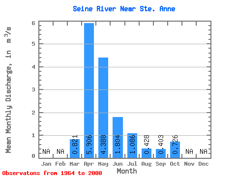
| Statistic | Jan | Feb | Mar | Apr | May | Jun | Jul | Aug | Sep | Oct | Nov | Dec | Annual |
|---|---|---|---|---|---|---|---|---|---|---|---|---|---|
| Mean | 0.82 | 5.91 | 4.39 | 1.80 | 1.09 | 0.43 | 0.40 | 0.73 | |||||
| Standard Deviation | 1.31 | 6.36 | 4.57 | 1.69 | 1.80 | 1.20 | 0.62 | 0.80 | |||||
| Min | 0.00 | 0.49 | 0.44 | 0.13 | 0.02 | 0.01 | 0.00 | 0.02 | |||||
| Max | 6.55 | 29.60 | 16.20 | 6.21 | 9.89 | 7.00 | 3.00 | 3.61 | |||||
| Coefficient of Variation | 1.60 | 1.08 | 1.04 | 0.94 | 1.66 | 2.81 | 1.55 | 1.09 |
 Return to R-Arctic Net Home Page