|
|
|||||||||||||||||
| Point ID: 3046 | Downloads | Plots | Site Data | Code: 05OH006 |
|
|
|||||||||||||||||
| Download | |
|---|---|
| Site Descriptor Information | Site Time Series Data |
| Link to all available data | |
| View: | Time Series | All |
| Units: | mm |
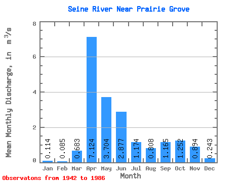
| Statistic | Jan | Feb | Mar | Apr | May | Jun | Jul | Aug | Sep | Oct | Nov | Dec | Annual |
|---|---|---|---|---|---|---|---|---|---|---|---|---|---|
| Mean | 0.11 | 0.09 | 0.68 | 7.12 | 3.70 | 2.88 | 1.17 | 0.81 | 1.17 | 1.25 | 0.89 | 0.24 | 1.49 |
| Standard Deviation | 0.09 | 0.07 | 1.85 | 5.81 | 5.18 | 3.76 | 1.12 | 1.77 | 3.17 | 2.48 | 1.26 | 0.16 | 1.21 |
| Min | 0.00 | 0.00 | 0.00 | 0.79 | 0.44 | 0.13 | 0.04 | 0.01 | 0.01 | 0.06 | 0.07 | 0.00 | 0.38 |
| Max | 0.40 | 0.26 | 11.30 | 26.00 | 33.80 | 19.60 | 5.45 | 10.70 | 20.40 | 16.00 | 6.69 | 0.54 | 5.71 |
| Coefficient of Variation | 0.75 | 0.78 | 2.71 | 0.81 | 1.40 | 1.30 | 0.95 | 2.19 | 2.72 | 1.98 | 1.41 | 0.68 | 0.81 |
 Return to R-Arctic Net Home Page