|
|
|||||||||||||||||
| Point ID: 304 | Downloads | Plots | Site Data | Code: 05BL004 |
|
|
|||||||||||||||||
| Download | |
|---|---|
| Site Descriptor Information | Site Time Series Data |
| Link to all available data | |
| View: | Time Series | All |
| Units: | mm |
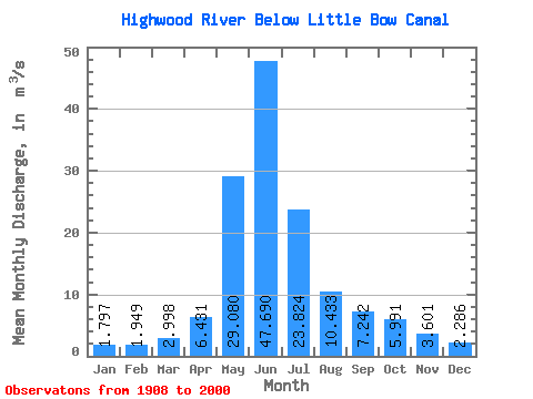
| Statistic | Jan | Feb | Mar | Apr | May | Jun | Jul | Aug | Sep | Oct | Nov | Dec | Annual |
|---|---|---|---|---|---|---|---|---|---|---|---|---|---|
| Mean | 1.80 | 1.95 | 3.00 | 6.43 | 29.08 | 47.69 | 23.82 | 10.43 | 7.24 | 5.99 | 3.60 | 2.29 | 11.82 |
| Standard Deviation | 0.67 | 0.82 | 2.06 | 2.13 | 14.29 | 25.27 | 16.85 | 6.99 | 6.14 | 3.09 | 1.73 | 0.91 | 5.44 |
| Min | 0.77 | 0.75 | 1.11 | 3.12 | 8.18 | 9.37 | 3.35 | 3.03 | 2.06 | 2.59 | 1.26 | 1.16 | 4.52 |
| Max | 3.35 | 3.95 | 8.47 | 10.90 | 58.60 | 108.00 | 59.20 | 26.80 | 27.60 | 12.30 | 6.60 | 3.99 | 21.53 |
| Coefficient of Variation | 0.37 | 0.42 | 0.69 | 0.33 | 0.49 | 0.53 | 0.71 | 0.67 | 0.85 | 0.52 | 0.48 | 0.40 | 0.46 |
 Return to R-Arctic Net Home Page