|
|
|||||||||||||||||
| Point ID: 3032 | Downloads | Plots | Site Data | Code: 05OF020 |
|
|
|||||||||||||||||
| Download | |
|---|---|
| Site Descriptor Information | Site Time Series Data |
| Link to all available data | |
| View: | Time Series | All |
| Units: | mm |
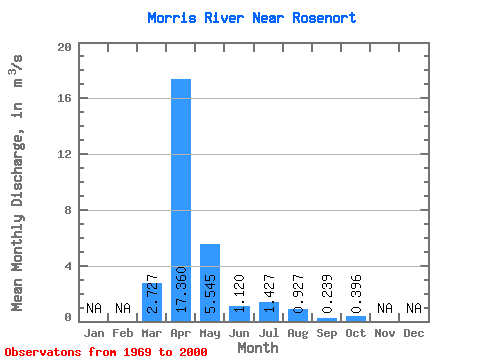
| Statistic | Jan | Feb | Mar | Apr | May | Jun | Jul | Aug | Sep | Oct | Nov | Dec | Annual |
|---|---|---|---|---|---|---|---|---|---|---|---|---|---|
| Mean | 2.73 | 17.36 | 5.54 | 1.12 | 1.43 | 0.93 | 0.24 | 0.40 | |||||
| Standard Deviation | 5.18 | 15.14 | 10.57 | 1.00 | 3.15 | 3.13 | 0.33 | 1.18 | |||||
| Min | 0.00 | 0.37 | 0.26 | 0.02 | 0.00 | 0.00 | 0.00 | 0.00 | |||||
| Max | 24.00 | 57.90 | 39.60 | 3.19 | 12.80 | 16.20 | 1.36 | 6.17 | |||||
| Coefficient of Variation | 1.90 | 0.87 | 1.91 | 0.89 | 2.21 | 3.37 | 1.39 | 2.97 |
 Return to R-Arctic Net Home Page