|
|
|||||||||||||||||
| Point ID: 3029 | Downloads | Plots | Site Data | Code: 05OF017 |
|
|
|||||||||||||||||
| Download | |
|---|---|
| Site Descriptor Information | Site Time Series Data |
| Link to all available data | |
| View: | Time Series | All |
| Units: | mm |
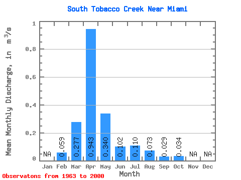
| Statistic | Jan | Feb | Mar | Apr | May | Jun | Jul | Aug | Sep | Oct | Nov | Dec | Annual |
|---|---|---|---|---|---|---|---|---|---|---|---|---|---|
| Mean | 0.06 | 0.28 | 0.94 | 0.34 | 0.10 | 0.11 | 0.07 | 0.03 | 0.03 | ||||
| Standard Deviation | 0.40 | 0.89 | 0.45 | 0.12 | 0.19 | 0.26 | 0.08 | 0.10 | |||||
| Min | 0.06 | 0.00 | 0.01 | 0.00 | 0.00 | 0.00 | 0.00 | 0.00 | 0.00 | ||||
| Max | 0.06 | 1.55 | 3.42 | 1.67 | 0.50 | 0.72 | 1.45 | 0.36 | 0.47 | ||||
| Coefficient of Variation | 1.45 | 0.95 | 1.32 | 1.14 | 1.70 | 3.64 | 2.74 | 2.81 |
 Return to R-Arctic Net Home Page