|
|
|||||||||||||||||
| Point ID: 3024 | Downloads | Plots | Site Data | Code: 05OF011 |
|
|
|||||||||||||||||
| Download | |
|---|---|
| Site Descriptor Information | Site Time Series Data |
| Link to all available data | |
| View: | Time Series | All |
| Units: | mm |
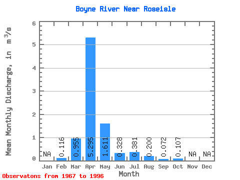
| Statistic | Jan | Feb | Mar | Apr | May | Jun | Jul | Aug | Sep | Oct | Nov | Dec | Annual |
|---|---|---|---|---|---|---|---|---|---|---|---|---|---|
| Mean | 0.12 | 0.95 | 5.29 | 1.61 | 0.33 | 0.38 | 0.20 | 0.07 | 0.11 | ||||
| Standard Deviation | 1.69 | 4.88 | 2.38 | 0.34 | 0.70 | 0.42 | 0.12 | 0.14 | |||||
| Min | 0.12 | 0.00 | 0.19 | 0.08 | 0.01 | 0.00 | 0.00 | 0.00 | 0.00 | ||||
| Max | 0.12 | 7.39 | 16.80 | 9.85 | 1.37 | 2.93 | 1.85 | 0.50 | 0.66 | ||||
| Coefficient of Variation | 1.77 | 0.92 | 1.48 | 1.04 | 1.84 | 2.09 | 1.71 | 1.31 |
 Return to R-Arctic Net Home Page