|
|
|||||||||||||||||
| Point ID: 3022 | Downloads | Plots | Site Data | Code: 05OF009 |
|
|
|||||||||||||||||
| Download | |
|---|---|
| Site Descriptor Information | Site Time Series Data |
| Link to all available data | |
| View: | Time Series | All |
| Units: | mm |
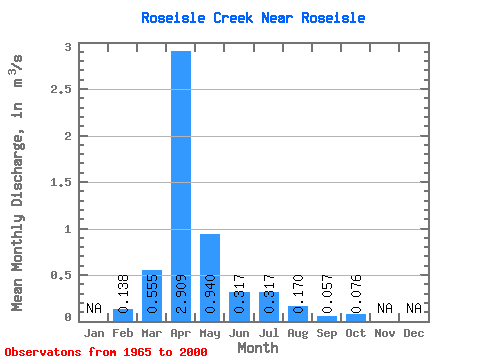
| Statistic | Jan | Feb | Mar | Apr | May | Jun | Jul | Aug | Sep | Oct | Nov | Dec | Annual |
|---|---|---|---|---|---|---|---|---|---|---|---|---|---|
| Mean | 0.14 | 0.56 | 2.91 | 0.94 | 0.32 | 0.32 | 0.17 | 0.06 | 0.08 | ||||
| Standard Deviation | 0.84 | 2.30 | 1.23 | 0.36 | 0.56 | 0.48 | 0.14 | 0.15 | |||||
| Min | 0.14 | 0.00 | 0.08 | 0.07 | 0.01 | 0.00 | 0.00 | 0.00 | 0.00 | ||||
| Max | 0.14 | 3.14 | 7.81 | 5.57 | 1.43 | 2.53 | 2.34 | 0.77 | 0.62 | ||||
| Coefficient of Variation | 1.52 | 0.79 | 1.31 | 1.15 | 1.78 | 2.84 | 2.56 | 1.97 |
 Return to R-Arctic Net Home Page