|
|
|||||||||||||||||
| Point ID: 3020 | Downloads | Plots | Site Data | Code: 05OF006 |
|
|
|||||||||||||||||
| Download | |
|---|---|
| Site Descriptor Information | Site Time Series Data |
| Link to all available data | |
| View: | Time Series | All |
| Units: | mm |
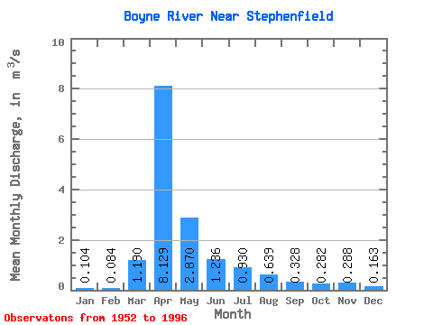
| Statistic | Jan | Feb | Mar | Apr | May | Jun | Jul | Aug | Sep | Oct | Nov | Dec | Annual |
|---|---|---|---|---|---|---|---|---|---|---|---|---|---|
| Mean | 0.10 | 0.08 | 1.19 | 8.13 | 2.87 | 1.24 | 0.93 | 0.64 | 0.33 | 0.28 | 0.29 | 0.16 | 1.35 |
| Standard Deviation | 0.09 | 0.06 | 2.00 | 6.85 | 3.81 | 1.60 | 1.44 | 1.25 | 0.48 | 0.31 | 0.32 | 0.14 | 0.89 |
| Min | 0.00 | 0.00 | 0.00 | 0.02 | 0.29 | 0.07 | 0.02 | 0.01 | 0.01 | 0.01 | 0.00 | 0.00 | 0.18 |
| Max | 0.43 | 0.22 | 9.57 | 24.10 | 17.80 | 7.82 | 6.64 | 6.12 | 2.17 | 1.16 | 1.39 | 0.57 | 3.59 |
| Coefficient of Variation | 0.84 | 0.69 | 1.68 | 0.84 | 1.33 | 1.29 | 1.54 | 1.95 | 1.47 | 1.09 | 1.12 | 0.87 | 0.66 |
 Return to R-Arctic Net Home Page