|
|
|||||||||||||||||
| Point ID: 302 | Downloads | Plots | Site Data | Code: 05BK003 |
|
|
|||||||||||||||||
| Download | |
|---|---|
| Site Descriptor Information | Site Time Series Data |
| Link to all available data | |
| View: | Time Series | All |
| Units: | mm |
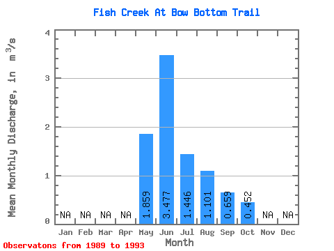
| Statistic | Jan | Feb | Mar | Apr | May | Jun | Jul | Aug | Sep | Oct | Nov | Dec | Annual |
|---|---|---|---|---|---|---|---|---|---|---|---|---|---|
| Mean | 1.86 | 3.48 | 1.45 | 1.10 | 0.66 | 0.45 | |||||||
| Standard Deviation | 1.11 | 1.09 | 1.14 | 1.18 | 0.81 | 0.37 | |||||||
| Min | 0.34 | 1.93 | 0.15 | 0.08 | 0.15 | 0.14 | |||||||
| Max | 2.98 | 4.27 | 3.19 | 3.04 | 2.09 | 1.06 | |||||||
| Coefficient of Variation | 0.60 | 0.31 | 0.79 | 1.07 | 1.24 | 0.82 |
 Return to R-Arctic Net Home Page