|
|
|||||||||||||||||
| Point ID: 3009 | Downloads | Plots | Site Data | Code: 05OE006 |
|
|
|||||||||||||||||
| Download | |
|---|---|
| Site Descriptor Information | Site Time Series Data |
| Link to all available data | |
| View: | Time Series | All |
| Units: | mm |
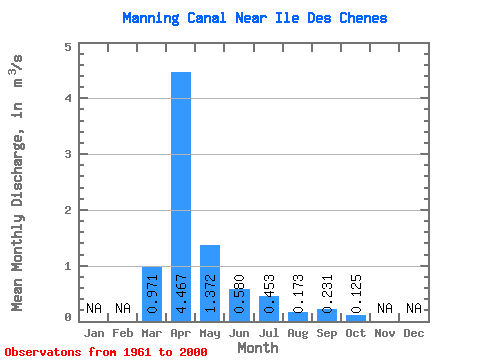
| Statistic | Jan | Feb | Mar | Apr | May | Jun | Jul | Aug | Sep | Oct | Nov | Dec | Annual |
|---|---|---|---|---|---|---|---|---|---|---|---|---|---|
| Mean | 0.97 | 4.47 | 1.37 | 0.58 | 0.45 | 0.17 | 0.23 | 0.12 | |||||
| Standard Deviation | 1.58 | 5.58 | 2.29 | 0.75 | 1.19 | 0.27 | 0.57 | 0.10 | |||||
| Min | 0.00 | 0.05 | 0.02 | 0.01 | 0.00 | 0.00 | 0.00 | 0.00 | |||||
| Max | 6.91 | 22.30 | 9.86 | 3.01 | 6.57 | 1.08 | 3.22 | 0.35 | |||||
| Coefficient of Variation | 1.63 | 1.25 | 1.67 | 1.29 | 2.62 | 1.54 | 2.49 | 0.76 |
 Return to R-Arctic Net Home Page