|
|
|||||||||||||||||
| Point ID: 3002 | Downloads | Plots | Site Data | Code: 05OD031 |
|
|
|||||||||||||||||
| Download | |
|---|---|
| Site Descriptor Information | Site Time Series Data |
| Link to all available data | |
| View: | Time Series | All |
| Units: | mm |
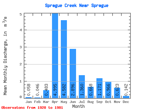
| Statistic | Jan | Feb | Mar | Apr | May | Jun | Jul | Aug | Sep | Oct | Nov | Dec | Annual |
|---|---|---|---|---|---|---|---|---|---|---|---|---|---|
| Mean | 0.06 | 0.05 | 0.48 | 5.00 | 4.58 | 2.90 | 1.36 | 0.67 | 1.17 | 0.97 | 0.62 | 0.14 | 1.65 |
| Standard Deviation | 0.05 | 0.03 | 0.99 | 3.96 | 4.10 | 2.72 | 1.83 | 1.05 | 2.37 | 1.44 | 0.68 | 0.14 | 0.91 |
| Min | 0.01 | 0.00 | 0.01 | 0.20 | 0.06 | 0.00 | 0.00 | 0.00 | 0.01 | 0.03 | 0.03 | 0.01 | 0.16 |
| Max | 0.29 | 0.12 | 5.46 | 17.90 | 20.10 | 12.20 | 8.93 | 4.54 | 11.90 | 7.33 | 3.06 | 0.81 | 3.58 |
| Coefficient of Variation | 0.81 | 0.58 | 2.05 | 0.79 | 0.89 | 0.94 | 1.34 | 1.58 | 2.02 | 1.49 | 1.09 | 1.00 | 0.55 |
 Return to R-Arctic Net Home Page