|
|
|||||||||||||||||
| Point ID: 30 | Downloads | Plots | Site Data | Code: 05AB007 |
|
|
|||||||||||||||||
| Download | |
|---|---|
| Site Descriptor Information | Site Time Series Data |
| Link to all available data | |
| View: | Time Series | All |
| Units: | mm |
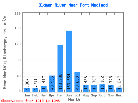
| Statistic | Jan | Feb | Mar | Apr | May | Jun | Jul | Aug | Sep | Oct | Nov | Dec | Annual |
|---|---|---|---|---|---|---|---|---|---|---|---|---|---|
| Mean | 9.38 | 9.71 | 14.42 | 40.93 | 118.29 | 153.95 | 49.65 | 17.43 | 17.79 | 19.10 | 16.77 | 11.25 | 38.28 |
| Standard Deviation | 4.00 | 6.53 | 8.57 | 24.67 | 52.17 | 92.14 | 35.66 | 15.80 | 22.72 | 15.79 | 9.17 | 4.94 | 15.69 |
| Min | 4.30 | 3.98 | 5.69 | 3.40 | 15.30 | 29.80 | 2.51 | 0.78 | 0.79 | 2.04 | 6.71 | 5.10 | 8.09 |
| Max | 24.20 | 37.20 | 38.30 | 115.00 | 244.00 | 446.00 | 143.00 | 58.90 | 115.00 | 59.30 | 38.90 | 26.10 | 74.90 |
| Coefficient of Variation | 0.43 | 0.67 | 0.59 | 0.60 | 0.44 | 0.60 | 0.72 | 0.91 | 1.28 | 0.83 | 0.55 | 0.44 | 0.41 |
 Return to R-Arctic Net Home Page