|
|
|||||||||||||||||
| Point ID: 2984 | Downloads | Plots | Site Data | Code: 05OC015 |
|
|
|||||||||||||||||
| Download | |
|---|---|
| Site Descriptor Information | Site Time Series Data |
| Link to all available data | |
| View: | Time Series | All |
| Units: | mm |
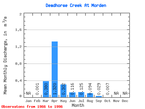
| Statistic | Jan | Feb | Mar | Apr | May | Jun | Jul | Aug | Sep | Oct | Nov | Dec | Annual |
|---|---|---|---|---|---|---|---|---|---|---|---|---|---|
| Mean | 0.00 | 0.38 | 1.32 | 0.30 | 0.12 | 0.12 | 0.09 | 0.03 | 0.01 | ||||
| Standard Deviation | 0.66 | 1.68 | 0.44 | 0.21 | 0.28 | 0.27 | 0.08 | 0.01 | |||||
| Min | 0.00 | 0.00 | 0.00 | 0.00 | 0.00 | 0.00 | 0.00 | 0.00 | 0.00 | ||||
| Max | 0.00 | 2.42 | 5.40 | 1.29 | 0.95 | 1.10 | 1.14 | 0.37 | 0.03 | ||||
| Coefficient of Variation | 1.73 | 1.27 | 1.45 | 1.80 | 2.25 | 2.84 | 2.82 | 1.38 |
 Return to R-Arctic Net Home Page