|
|
|||||||||||||||||
| Point ID: 2983 | Downloads | Plots | Site Data | Code: 05OC012 |
|
|
|||||||||||||||||
| Download | |
|---|---|
| Site Descriptor Information | Site Time Series Data |
| Link to all available data | |
| View: | Time Series | All |
| Units: | mm |
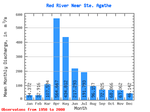
| Statistic | Jan | Feb | Mar | Apr | May | Jun | Jul | Aug | Sep | Oct | Nov | Dec | Annual |
|---|---|---|---|---|---|---|---|---|---|---|---|---|---|
| Mean | 34.37 | 32.92 | 107.59 | 564.67 | 434.81 | 217.29 | 191.79 | 96.16 | 72.92 | 68.87 | 67.06 | 46.14 | 166.75 |
| Standard Deviation | 19.30 | 17.77 | 129.04 | 351.35 | 495.53 | 163.06 | 178.53 | 135.09 | 72.50 | 49.79 | 76.23 | 32.46 | 93.09 |
| Min | 3.41 | 5.36 | 8.24 | 54.20 | 39.40 | 27.20 | 14.40 | 8.23 | 8.54 | 8.53 | 7.61 | 4.57 | 25.00 |
| Max | 76.20 | 76.00 | 648.00 | 1530.00 | 2240.00 | 743.00 | 837.00 | 871.00 | 344.00 | 227.00 | 476.00 | 148.00 | 409.81 |
| Coefficient of Variation | 0.56 | 0.54 | 1.20 | 0.62 | 1.14 | 0.75 | 0.93 | 1.41 | 0.99 | 0.72 | 1.14 | 0.70 | 0.56 |
 Return to R-Arctic Net Home Page