|
|
|||||||||||||||||
| Point ID: 2975 | Downloads | Plots | Site Data | Code: 05OB021 |
|
|
|||||||||||||||||
| Download | |
|---|---|
| Site Descriptor Information | Site Time Series Data |
| Link to all available data | |
| View: | Time Series | All |
| Units: | mm |
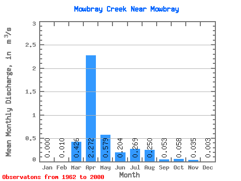
| Statistic | Jan | Feb | Mar | Apr | May | Jun | Jul | Aug | Sep | Oct | Nov | Dec | Annual |
|---|---|---|---|---|---|---|---|---|---|---|---|---|---|
| Mean | 0.00 | 0.01 | 0.43 | 2.27 | 0.58 | 0.20 | 0.27 | 0.25 | 0.05 | 0.06 | 0.04 | 0.00 | 0.51 |
| Standard Deviation | 0.00 | 0.04 | 0.79 | 2.45 | 1.07 | 0.34 | 0.89 | 0.95 | 0.15 | 0.26 | 0.12 | 0.01 | 0.49 |
| Min | 0.00 | 0.00 | 0.00 | 0.01 | 0.00 | 0.00 | 0.00 | 0.00 | 0.00 | 0.00 | 0.00 | 0.00 | 0.02 |
| Max | 0.00 | 0.16 | 3.47 | 9.75 | 4.51 | 1.64 | 5.36 | 4.56 | 0.81 | 1.60 | 0.47 | 0.04 | 1.63 |
| Coefficient of Variation | 3.87 | 3.85 | 1.86 | 1.08 | 1.84 | 1.65 | 3.30 | 3.80 | 2.91 | 4.42 | 3.43 | 3.67 | 0.96 |
 Return to R-Arctic Net Home Page