|
|
|||||||||||||||||
| Point ID: 2971 | Downloads | Plots | Site Data | Code: 05OB010 |
|
|
|||||||||||||||||
| Download | |
|---|---|
| Site Descriptor Information | Site Time Series Data |
| Link to all available data | |
| View: | Time Series | All |
| Units: | mm |
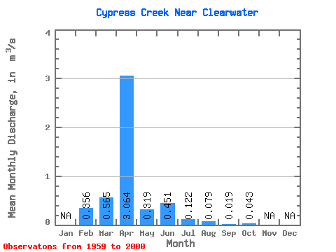
| Statistic | Jan | Feb | Mar | Apr | May | Jun | Jul | Aug | Sep | Oct | Nov | Dec | Annual |
|---|---|---|---|---|---|---|---|---|---|---|---|---|---|
| Mean | 0.36 | 0.56 | 3.06 | 0.32 | 0.45 | 0.12 | 0.08 | 0.02 | 0.04 | ||||
| Standard Deviation | 1.10 | 3.52 | 0.57 | 1.38 | 0.26 | 0.20 | 0.08 | 0.25 | |||||
| Min | 0.36 | 0.00 | 0.01 | 0.00 | 0.00 | 0.00 | 0.00 | 0.00 | 0.00 | ||||
| Max | 0.36 | 4.63 | 13.80 | 2.40 | 7.58 | 1.14 | 0.90 | 0.51 | 1.54 | ||||
| Coefficient of Variation | 1.95 | 1.15 | 1.78 | 3.06 | 2.17 | 2.58 | 4.34 | 5.84 |
 Return to R-Arctic Net Home Page