|
|
|||||||||||||||||
| Point ID: 2967 | Downloads | Plots | Site Data | Code: 05OB003 |
|
|
|||||||||||||||||
| Download | |
|---|---|
| Site Descriptor Information | Site Time Series Data |
| Link to all available data | |
| View: | Time Series | All |
| Units: | mm |
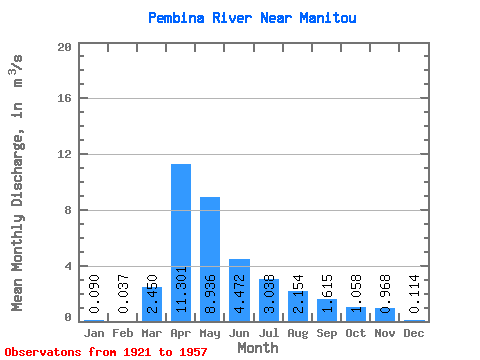
| Statistic | Jan | Feb | Mar | Apr | May | Jun | Jul | Aug | Sep | Oct | Nov | Dec | Annual |
|---|---|---|---|---|---|---|---|---|---|---|---|---|---|
| Mean | 0.09 | 0.04 | 2.45 | 11.30 | 8.94 | 4.47 | 3.04 | 2.15 | 1.61 | 1.06 | 0.97 | 0.11 | |
| Standard Deviation | 3.42 | 11.54 | 10.52 | 5.06 | 4.87 | 3.48 | 2.31 | 1.41 | 1.34 | ||||
| Min | 0.09 | 0.04 | 0.00 | 0.30 | 0.10 | 0.01 | 0.00 | 0.00 | 0.00 | 0.00 | 0.00 | 0.11 | |
| Max | 0.09 | 0.04 | 11.30 | 58.80 | 45.10 | 24.80 | 22.30 | 17.40 | 8.81 | 5.96 | 3.54 | 0.11 | |
| Coefficient of Variation | 1.40 | 1.02 | 1.18 | 1.13 | 1.60 | 1.62 | 1.43 | 1.33 | 1.38 |
 Return to R-Arctic Net Home Page