|
|
|||||||||||||||||
| Point ID: 2965 | Downloads | Plots | Site Data | Code: 05OA015 |
|
|
|||||||||||||||||
| Download | |
|---|---|
| Site Descriptor Information | Site Time Series Data |
| Link to all available data | |
| View: | Time Series | All |
| Units: | mm |
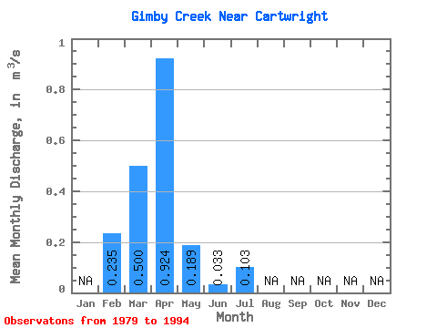
| Statistic | Jan | Feb | Mar | Apr | May | Jun | Jul | Aug | Sep | Oct | Nov | Dec | Annual |
|---|---|---|---|---|---|---|---|---|---|---|---|---|---|
| Mean | 0.23 | 0.50 | 0.92 | 0.19 | 0.03 | 0.10 | |||||||
| Standard Deviation | 0.81 | 1.42 | 0.44 | 0.05 | |||||||||
| Min | 0.23 | 0.00 | 0.01 | 0.00 | 0.00 | 0.10 | |||||||
| Max | 0.23 | 2.94 | 5.33 | 1.79 | 0.17 | 0.10 | |||||||
| Coefficient of Variation | 1.62 | 1.54 | 2.33 | 1.51 |
 Return to R-Arctic Net Home Page