|
|
|||||||||||||||||
| Point ID: 2963 | Downloads | Plots | Site Data | Code: 05OA013 |
|
|
|||||||||||||||||
| Download | |
|---|---|
| Site Descriptor Information | Site Time Series Data |
| Link to all available data | |
| View: | Time Series | All |
| Units: | mm |
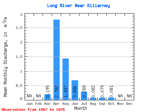
| Statistic | Jan | Feb | Mar | Apr | May | Jun | Jul | Aug | Sep | Oct | Nov | Dec | Annual |
|---|---|---|---|---|---|---|---|---|---|---|---|---|---|
| Mean | 0.20 | 2.78 | 1.44 | 0.69 | 0.29 | 0.08 | 0.08 | 0.08 | |||||
| Standard Deviation | 0.37 | 2.37 | 1.25 | 0.49 | 0.37 | 0.12 | 0.17 | 0.09 | |||||
| Min | 0.00 | 0.15 | 0.15 | 0.01 | 0.00 | 0.00 | 0.00 | 0.00 | |||||
| Max | 1.18 | 7.32 | 4.26 | 1.46 | 1.03 | 0.34 | 0.56 | 0.24 | |||||
| Coefficient of Variation | 1.90 | 0.85 | 0.87 | 0.72 | 1.29 | 1.52 | 2.20 | 1.06 |
 Return to R-Arctic Net Home Page