|
|
|||||||||||||||||
| Point ID: 2953 | Downloads | Plots | Site Data | Code: 05NG028 |
|
|
|||||||||||||||||
| Download | |
|---|---|
| Site Descriptor Information | Site Time Series Data |
| Link to all available data | |
| View: | Time Series | All |
| Units: | mm |
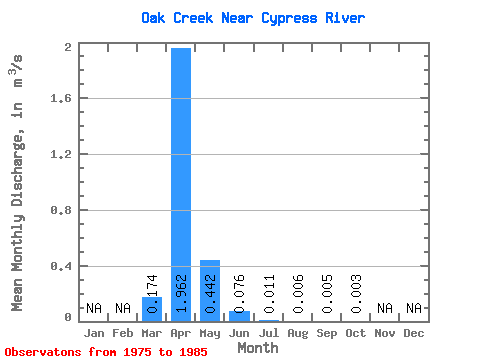
| Statistic | Jan | Feb | Mar | Apr | May | Jun | Jul | Aug | Sep | Oct | Nov | Dec | Annual |
|---|---|---|---|---|---|---|---|---|---|---|---|---|---|
| Mean | 0.17 | 1.96 | 0.44 | 0.08 | 0.01 | 0.01 | 0.01 | 0.00 | |||||
| Standard Deviation | 0.42 | 3.01 | 0.68 | 0.07 | 0.01 | 0.01 | 0.01 | 0.01 | |||||
| Min | 0.00 | 0.00 | 0.03 | 0.00 | 0.00 | 0.00 | 0.00 | 0.00 | |||||
| Max | 1.42 | 9.77 | 2.27 | 0.24 | 0.02 | 0.04 | 0.05 | 0.03 | |||||
| Coefficient of Variation | 2.40 | 1.53 | 1.53 | 0.99 | 0.81 | 2.13 | 3.25 | 3.02 |
 Return to R-Arctic Net Home Page