|
|
|||||||||||||||||
| Point ID: 2947 | Downloads | Plots | Site Data | Code: 05NG019 |
|
|
|||||||||||||||||
| Download | |
|---|---|
| Site Descriptor Information | Site Time Series Data |
| Link to all available data | |
| View: | Time Series | All |
| Units: | mm |
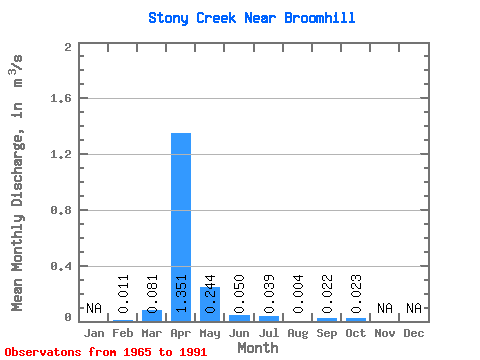
| Statistic | Jan | Feb | Mar | Apr | May | Jun | Jul | Aug | Sep | Oct | Nov | Dec | Annual |
|---|---|---|---|---|---|---|---|---|---|---|---|---|---|
| Mean | 0.01 | 0.08 | 1.35 | 0.24 | 0.05 | 0.04 | 0.00 | 0.02 | 0.02 | ||||
| Standard Deviation | 0.19 | 2.95 | 0.45 | 0.10 | 0.14 | 0.01 | 0.09 | 0.09 | |||||
| Min | 0.01 | 0.00 | 0.00 | 0.00 | 0.00 | 0.00 | 0.00 | 0.00 | 0.00 | ||||
| Max | 0.01 | 0.84 | 14.50 | 1.86 | 0.41 | 0.73 | 0.08 | 0.46 | 0.43 | ||||
| Coefficient of Variation | 2.36 | 2.18 | 1.83 | 2.10 | 3.56 | 4.18 | 4.08 | 3.87 |
 Return to R-Arctic Net Home Page