|
|
|||||||||||||||||
| Point ID: 2928 | Downloads | Plots | Site Data | Code: 05NF002 |
|
|
|||||||||||||||||
| Download | |
|---|---|
| Site Descriptor Information | Site Time Series Data |
| Link to all available data | |
| View: | Time Series | All |
| Units: | mm |
| Statistic | Jan | Feb | Mar | Apr | May | Jun | Jul | Aug | Sep | Oct | Nov | Dec | Annual |
|---|---|---|---|---|---|---|---|---|---|---|---|---|---|
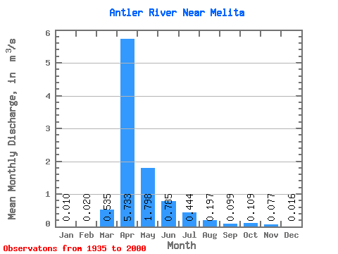
| Mean | 0.01 | 0.02 | 0.54 | 5.73 | 1.80 | 0.79 | 0.44 | 0.20 | 0.10 | 0.11 | 0.08 | 0.02 | 0.44 |
| Standard Deviation | 0.02 | 0.05 | 1.30 | 9.71 | 3.25 | 1.25 | 0.81 | 0.55 | 0.34 | 0.41 | 0.20 | 0.04 | 0.53 |
| Min | 0.00 | 0.00 | 0.00 | 0.00 | 0.00 | 0.00 | 0.00 | 0.00 | 0.00 | 0.00 | 0.00 | 0.00 | 0.00 |
| Max | 0.09 | 0.23 | 6.88 | 63.30 | 14.40 | 5.57 | 3.91 | 3.37 | 1.97 | 2.75 | 0.70 | 0.19 | 1.85 |
| Coefficient of Variation | 2.44 | 2.58 | 2.44 | 1.69 | 1.81 | 1.59 | 1.82 | 2.77 | 3.43 | 3.78 | 2.56 | 2.71 | 1.21 |
 Return to R-Arctic Net Home Page