|
|
|||||||||||||||||
| Point ID: 2903 | Downloads | Plots | Site Data | Code: 05MG008 |
|
|
|||||||||||||||||
| Download | |
|---|---|
| Site Descriptor Information | Site Time Series Data |
| Link to all available data | |
| View: | Time Series | All |
| Units: | mm |
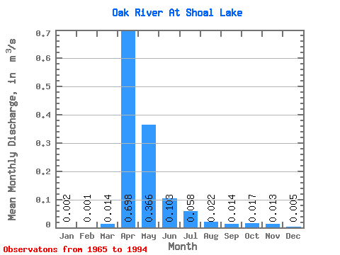
| Statistic | Jan | Feb | Mar | Apr | May | Jun | Jul | Aug | Sep | Oct | Nov | Dec | Annual |
|---|---|---|---|---|---|---|---|---|---|---|---|---|---|
| Mean | 0.00 | 0.00 | 0.01 | 0.70 | 0.37 | 0.10 | 0.06 | 0.02 | 0.01 | 0.02 | 0.01 | 0.01 | 0.12 |
| Standard Deviation | 0.01 | 0.00 | 0.03 | 0.92 | 0.49 | 0.15 | 0.09 | 0.04 | 0.06 | 0.07 | 0.05 | 0.02 | 0.15 |
| Min | 0.00 | 0.00 | 0.00 | 0.00 | 0.00 | 0.00 | 0.00 | 0.00 | 0.00 | 0.00 | 0.00 | 0.00 | 0.00 |
| Max | 0.03 | 0.01 | 0.13 | 3.97 | 1.74 | 0.57 | 0.29 | 0.15 | 0.29 | 0.35 | 0.23 | 0.08 | 0.52 |
| Coefficient of Variation | 4.36 | 4.36 | 2.18 | 1.31 | 1.35 | 1.44 | 1.50 | 1.87 | 3.86 | 3.91 | 3.93 | 4.14 | 1.18 |
 Return to R-Arctic Net Home Page