|
|
|||||||||||||||||
| Point ID: 2900 | Downloads | Plots | Site Data | Code: 05MG004 |
|
|
|||||||||||||||||
| Download | |
|---|---|
| Site Descriptor Information | Site Time Series Data |
| Link to all available data | |
| View: | Time Series | All |
| Units: | mm |
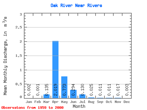
| Statistic | Jan | Feb | Mar | Apr | May | Jun | Jul | Aug | Sep | Oct | Nov | Dec | Annual |
|---|---|---|---|---|---|---|---|---|---|---|---|---|---|
| Mean | 0.00 | 0.00 | 0.14 | 2.02 | 0.77 | 0.29 | 0.13 | 0.03 | 0.01 | 0.01 | 0.02 | 0.00 | 0.33 |
| Standard Deviation | 0.01 | 0.01 | 0.26 | 2.29 | 1.69 | 0.54 | 0.26 | 0.06 | 0.03 | 0.03 | 0.05 | 0.01 | 0.32 |
| Min | 0.00 | 0.00 | 0.00 | 0.00 | 0.00 | 0.00 | 0.00 | 0.00 | 0.00 | 0.00 | 0.00 | 0.00 | 0.00 |
| Max | 0.03 | 0.02 | 0.92 | 9.09 | 10.10 | 2.41 | 1.20 | 0.29 | 0.18 | 0.17 | 0.20 | 0.05 | 1.09 |
| Coefficient of Variation | 4.09 | 3.89 | 1.94 | 1.14 | 2.19 | 1.83 | 1.96 | 2.48 | 2.99 | 3.01 | 2.93 | 3.82 | 0.98 |
 Return to R-Arctic Net Home Page