|
|
|||||||||||||||||
| Point ID: 29 | Downloads | Plots | Site Data | Code: 05AB006 |
|
|
|||||||||||||||||
| Download | |
|---|---|
| Site Descriptor Information | Site Time Series Data |
| Link to all available data | |
| View: | Time Series | All |
| Units: | mm |
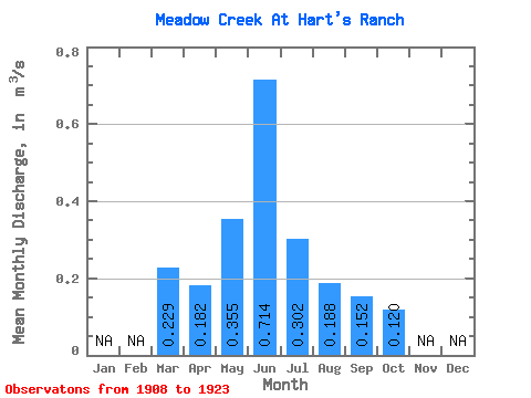
| Statistic | Jan | Feb | Mar | Apr | May | Jun | Jul | Aug | Sep | Oct | Nov | Dec | Annual |
|---|---|---|---|---|---|---|---|---|---|---|---|---|---|
| Mean | 0.23 | 0.18 | 0.35 | 0.71 | 0.30 | 0.19 | 0.15 | 0.12 | |||||
| Standard Deviation | 0.35 | 0.08 | 0.44 | 1.12 | 0.31 | 0.18 | 0.20 | 0.10 | |||||
| Min | 0.05 | 0.10 | 0.03 | 0.00 | 0.00 | 0.00 | 0.00 | 0.00 | |||||
| Max | 0.76 | 0.36 | 1.53 | 3.87 | 0.94 | 0.59 | 0.72 | 0.34 | |||||
| Coefficient of Variation | 1.54 | 0.42 | 1.24 | 1.57 | 1.04 | 0.97 | 1.28 | 0.80 |
 Return to R-Arctic Net Home Page