|
|
|||||||||||||||||
| Point ID: 2886 | Downloads | Plots | Site Data | Code: 05MF001 |
|
|
|||||||||||||||||
| Download | |
|---|---|
| Site Descriptor Information | Site Time Series Data |
| Link to all available data | |
| View: | Time Series | All |
| Units: | mm |
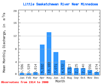
| Statistic | Jan | Feb | Mar | Apr | May | Jun | Jul | Aug | Sep | Oct | Nov | Dec | Annual |
|---|---|---|---|---|---|---|---|---|---|---|---|---|---|
| Mean | 0.59 | 0.54 | 0.81 | 9.33 | 13.18 | 7.07 | 4.57 | 2.33 | 2.12 | 2.14 | 1.56 | 0.87 | 3.70 |
| Standard Deviation | 0.51 | 0.48 | 0.69 | 6.61 | 11.65 | 5.88 | 4.66 | 2.44 | 3.69 | 2.76 | 1.40 | 0.73 | 2.03 |
| Min | 0.00 | 0.00 | 0.00 | 1.80 | 0.80 | 0.37 | 0.20 | 0.07 | 0.05 | 0.10 | 0.25 | 0.15 | 0.82 |
| Max | 2.90 | 2.63 | 3.37 | 32.40 | 49.30 | 27.60 | 17.50 | 12.00 | 26.30 | 19.30 | 7.58 | 3.70 | 9.20 |
| Coefficient of Variation | 0.87 | 0.89 | 0.84 | 0.71 | 0.88 | 0.83 | 1.02 | 1.05 | 1.74 | 1.29 | 0.90 | 0.83 | 0.55 |
 Return to R-Arctic Net Home Page