|
|
|||||||||||||||||
| Point ID: 2876 | Downloads | Plots | Site Data | Code: 05MD002 |
|
|
|||||||||||||||||
| Download | |
|---|---|
| Site Descriptor Information | Site Time Series Data |
| Link to all available data | |
| View: | Time Series | All |
| Units: | mm |
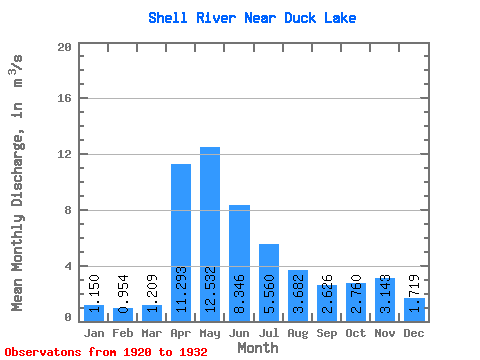
| Statistic | Jan | Feb | Mar | Apr | May | Jun | Jul | Aug | Sep | Oct | Nov | Dec | Annual |
|---|---|---|---|---|---|---|---|---|---|---|---|---|---|
| Mean | 1.15 | 0.95 | 1.21 | 11.29 | 12.53 | 8.35 | 5.56 | 3.68 | 2.63 | 2.76 | 3.14 | 1.72 | 5.74 |
| Standard Deviation | 0.47 | 0.41 | 0.57 | 7.05 | 12.53 | 5.49 | 3.72 | 2.92 | 1.54 | 1.65 | 1.60 | 0.79 | 1.96 |
| Min | 0.61 | 0.15 | 0.22 | 1.66 | 2.00 | 1.57 | 1.36 | 0.86 | 1.04 | 1.11 | 1.50 | 1.13 | 3.36 |
| Max | 1.82 | 1.33 | 1.88 | 21.60 | 45.00 | 19.00 | 13.70 | 10.60 | 6.31 | 6.31 | 6.47 | 3.41 | 8.58 |
| Coefficient of Variation | 0.41 | 0.43 | 0.47 | 0.62 | 1.00 | 0.66 | 0.67 | 0.79 | 0.59 | 0.60 | 0.51 | 0.46 | 0.34 |
 Return to R-Arctic Net Home Page