|
|
|||||||||||||||||
| Point ID: 2872 | Downloads | Plots | Site Data | Code: 05LM006 |
|
|
|||||||||||||||||
| Download | |
|---|---|
| Site Descriptor Information | Site Time Series Data |
| Link to all available data | |
| View: | Time Series | All |
| Units: | mm |
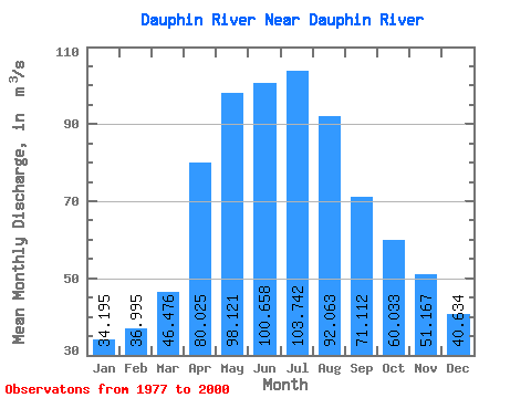
| Statistic | Jan | Feb | Mar | Apr | May | Jun | Jul | Aug | Sep | Oct | Nov | Dec | Annual |
|---|---|---|---|---|---|---|---|---|---|---|---|---|---|
| Mean | 34.20 | 36.99 | 46.48 | 80.03 | 98.12 | 100.66 | 103.74 | 92.06 | 71.11 | 60.03 | 51.17 | 40.63 | 67.94 |
| Standard Deviation | 29.60 | 31.57 | 37.40 | 40.89 | 62.58 | 83.69 | 83.59 | 79.15 | 62.87 | 52.95 | 40.56 | 31.43 | 44.09 |
| Min | 1.50 | 0.66 | 2.11 | 19.80 | 29.60 | 21.20 | 15.60 | 15.00 | 12.30 | 12.60 | 10.30 | 4.70 | 15.45 |
| Max | 96.50 | 112.00 | 129.00 | 144.00 | 255.00 | 313.00 | 312.00 | 272.00 | 201.00 | 196.00 | 135.00 | 116.00 | 154.01 |
| Coefficient of Variation | 0.87 | 0.85 | 0.81 | 0.51 | 0.64 | 0.83 | 0.81 | 0.86 | 0.88 | 0.88 | 0.79 | 0.77 | 0.65 |
 Return to R-Arctic Net Home Page