|
|
|||||||||||||||||
| Point ID: 2870 | Downloads | Plots | Site Data | Code: 05LL028 |
|
|
|||||||||||||||||
| Download | |
|---|---|
| Site Descriptor Information | Site Time Series Data |
| Link to all available data | |
| View: | Time Series | All |
| Units: | mm |
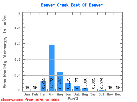
| Statistic | Jan | Feb | Mar | Apr | May | Jun | Jul | Aug | Sep | Oct | Nov | Dec | Annual |
|---|---|---|---|---|---|---|---|---|---|---|---|---|---|
| Mean | 0.26 | 1.17 | 0.48 | 0.20 | 0.13 | 0.08 | 0.00 | 0.02 | |||||
| Standard Deviation | 0.50 | 1.56 | 0.87 | 0.24 | 0.31 | 0.17 | 0.01 | 0.06 | |||||
| Min | 0.00 | 0.03 | 0.00 | 0.00 | 0.00 | 0.00 | 0.00 | 0.00 | |||||
| Max | 1.70 | 5.54 | 2.86 | 0.68 | 1.14 | 0.56 | 0.02 | 0.17 | |||||
| Coefficient of Variation | 1.91 | 1.33 | 1.81 | 1.19 | 2.45 | 2.17 | 2.01 | 2.38 |
 Return to R-Arctic Net Home Page